Jeff George
Jeff George was Chief Meteorologist and Director of FPREN from 2022-2023.
-
 A frontal boundary will slowly track through the Florida Panhandle starting late tonight. Abundant moisture will increase ahead of the system causing rounds of heavy rain and isolated severe storms Friday through Sunday.
 -
 The National Hurricane Center is monitoring an area of low pressure in the southwestern Gulf of Mexico. Regardless of development, heavy rain, strong storms, rough surf, and increased winds are expected Wednesday into Thursday.


-
 The forecast continues for Idalia to strengthen into a major category 3 hurricane and make landfall early Wednesday somewhere across the Big Bend Coast of Florida.
 -
 The National Hurricane Center is now forecasting Idalia to be a major category 3 hurricane at landfall early Wednesday. The most likely area for landfall is from Tallahassee to Sarasota, but to be safe, the entire Gulf Coast needs to prepare for high impacts.
 -
 Tropical Depression Ten has now intensified into Tropical Storm Idalia. The NHC is forecasting landfall as a Category 1 hurricane (winds up to 90 mph) along the Florida Gulf Coast on Wednesday.
 -
 The National Hurricane Center is now marking a spot from the northwest Caribbean into the eastern Gulf of Mexico with a moderate chance for development. Tropical Storm Franklin is now becoming better organized will likely become a hurricane over the weekend.
 -
 Tropical Storm Harold made landfall on Padre Island late this morning with max sustained winds of 50 mph. Franklin is still forecasted to turn into a weak hurricane this weekend.
 -
 We still have 5 areas of interest that are dominating the tropics today.
 -
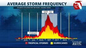 The month of August begins a rapid climb to the climatological peak of hurricane season on September 10th. Historically, 90% of all hurricanes and 95% of all major hurricanes happen after August 1st.
 -
 A tropical wave has formed in the southwestern Atlantic this afternoon and is now tracking right toward the southeast U.S. It's a weak area of low pressure that just popped up on the weather maps earlier today a few hundred miles south of Bermuda.
 -
 The tropics will need to be monitored even closer than normal for late July. In the Atlantic, we have a tropical storm and another system that may be a depression before the weekend is over.
 -
 Tropical Storms Bret and Cindy are strong systems on 2 different paths, but both will become depressions without ever reaching hurricane status.


