-
 In Florida, hurricane danger does not begin at landfall. Outer bands, tornadoes, and worsening travel conditions can start hours earlier, making timing one of the most important parts of storm preparation.
 -
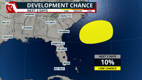 The remnants of a cold front could leave enough energy behind over the western Atlantic to ignite tropical storm activity east of Florida. What are the chances of this system developing, and where could it go?


-
 On Thursday, temperatures were already hot across much of the Florida Peninsula, with roughly two-thirds of the state under a Heat Advisory. Not only were air temperatures high, but the combination of heat and humidity pushed heat index values as high as 110°F in some locations.
 -
 Tropical storm Arthur was short lived, lasting only about 6 hours. But forecasters are watching for increased flooding rain and storm chances across parts of Florida later this week.
 -
 Arthur became the first named system of the season, but in less than 6 hours after being named, it moved over land in Texas. The flash flood threat continues for the next couple of days across the Southeast.
 -
 Heavy rains threaten the Gulf Coast states, from Southeast Texas through the Deep South. Heavy rains could affect parts of the western Florida Panhandle.
 -
 A lower-category storm can still be deadly, and the kind of danger a hurricane brings often depends on which part of the state is in its path.
 -
 Dangerous heat is coming to North Florida and the Panhandle this weekend; the heat risk moves south next week.
 -
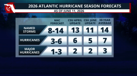 Colorado State lowers its 2026 Hurricane Season forecast due to a strong El Niño developing during the season. What does this mean?
 -
 Low rain chances for most of Florida & temperatures could feel like the triple digits across many areas this weekend. Read your forecast here.
 -
 In Florida, the forecast cone is only part of the story. Hurricane impacts can extend far beyond the center track — reaching inland through wind, flooding, and tornadoes.
 -
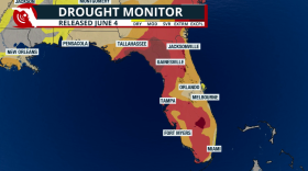 The exceptional drought has been cut in half! But not all rain has been accounted for in this drought report.


