For continuous wildfire coverage, tune in now to the YouTube stream from FPREN and WUFT. We’re tracking active wildfires across the state with the latest on fire movement, smoke conditions, and air quality impacts in your area. Stay informed as conditions change in real time.
-
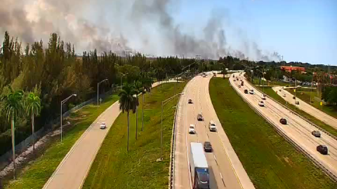 A large wildfire, started by lightning, is growing in size over western Broward County. The winds are helping move the smoke away from the metro southeast region, but the heat is not helping the firefighters.
 -
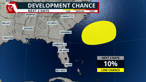 The remnants of a cold front could leave enough energy behind over the western Atlantic to ignite tropical storm activity east of Florida. What are the chances of this system developing, and where could it go?


-
 On Thursday, temperatures were already hot across much of the Florida Peninsula, with roughly two-thirds of the state under a Heat Advisory. Not only were air temperatures high, but the combination of heat and humidity pushed heat index values as high as 110°F in some locations.
 -
 Arthur became the first named system of the season, but in less than 6 hours after being named, it moved over land in Texas. The flash flood threat continues for the next couple of days across the Southeast.
 -
 Extremely hot temperatures and a late-afternoon storm make it hard for firefighters to contain the Quarry 2 fire burning in the Everglades, producing hazy skies, poor air quality, and burnt smells across South Florida.
 -
 Heavy rains threaten the Gulf Coast states, from Southeast Texas through the Deep South. Heavy rains could affect parts of the western Florida Panhandle.
 -
 Florida is known for its sunshine and heat, but the state’s hottest air temperature is actually lower than nearly every other state.
 -
 Dangerous heat is coming to North Florida and the Panhandle this weekend; the heat risk moves south next week.
 -
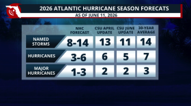 Colorado State lowers its 2026 Hurricane Season forecast due to a strong El Niño developing during the season. What does this mean?
 -
 Low rain chances for most of Florida & temperatures could feel like the triple digits across many areas this weekend. Read your forecast here.
 -
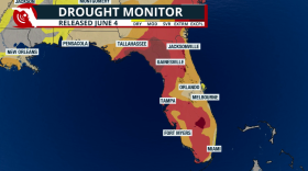 The exceptional drought has been cut in half! But not all rain has been accounted for in this drought report.
 -
 While a rare cold front will bring drier air across the northern half of the state, rain could meander across South Florida for the weekend, and winds bring hazardous conditions along the beaches.


