
Megan Borowski
Senior MeteorologistMegan Borowski is a Senior Meteorologist for the Florida Public Radio Emergency Network and has been with the organization since early 2019. A New Jersey native, Borowski completed her B.S. in Meteorology at Rutgers University. While in school, she served as an intern at WNBC in New York. After graduating, Borowski was a freelance meteorologist for ABC Network News in New York, where she produced weather for “Good Morning America” and “World News Tonight.” Borowski earned her M.S. at the University of Florida, where she researched high-resolution weather models. While she loves the science of meteorology, Borowski is also devoted to communicating essential forecast information to the public. She is dedicated to the mission of FPREN, which is to keep the public safe and informed during impactful weather events.
-
 Florida House Bill 7031 was signed on June 30 and eliminates state sales tax on hurricane kit essentials. The law takes effect Aug. 1.
 -
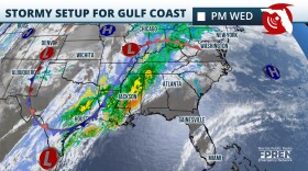
 Heavy rain and flash flooding are expected over parts of the peninsula as the system approaches from the Gulf by early to mid week.


-
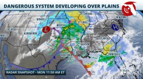
 A storm system developing over the Plains Thursday will create a risk for strong thunderstorms over the Panhandle and the I-10 corridor in North Florida late Friday and through the day Saturday.
 -
 Rounds of thunderstorms could lead to localized flooding over Florida's Panhandle. Meanwhile, over the peninsula, the warm trend will continue until the end of the weekend.
 -
 Freeze alerts are already in effect for the Panhandle and North Florida as temperatures are expected to drop to the lowest they've been in over a year.
 -
 Sub freezing lows are forecasted for the Panhandle and North Florida on Wednesday morning. Wind chills in the 30s are expected as far south as Tampa and Orlando.
 -
 Just days after strong storms and numerous tornadoes across the Panhandle, the risk for severe thunderstorms returns
 -
 The same system that produced damaging winds and tornado reports is entering the Florida peninsula this afternoon. Impacts to continue into the evening.
 -
 Multiple rounds of dangerous thunderstorms are expected as another strong winter storm barrels across the country. Damaging winds and a few tornadoes (potentially strong) are possible, especially over the Panhandle and North Florida.
 -
 Strong winds and 3-5 inches of rainfall are possible across most of the state this weekend. Before the main storm arrives, conditions to remain windy on Friday.
 -
 Scattered storms will impact parts of the state through Wednesday. Cooler and partly to mostly cloudy for the northern half of the state on Thanksgiving.
 -
 A Gulf Low and a Caribbean system will simultaneously impact Florida this week. Flooding winds and damaging wind gusts are expected over the Panhandle and South Florida


