
Irene Sans
Multimedia MeteorologistIrene Sans is an Emmy-winning, AMS-certified meteorologist (CBM, CDM) with more than 15 years of experience covering severe weather and climate stories across the U.S. and Latin America. A bilingual communicator and digital leader, she has delivered forecasts and science content for TV, radio, social media, and top weather platforms including Weather & Radar, WFTV, Telemundo, and The Weather Company. She has also served as Deputy State Meteorologist for Florida and consulted internationally on tropical forecasting and climate communications.
-
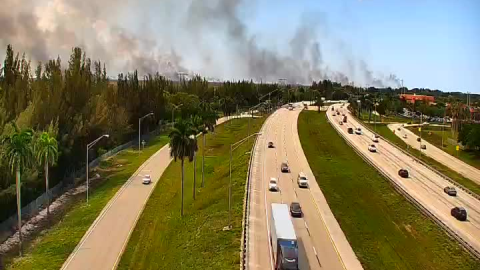 A large wildfire, started by lightning, is growing in size over western Broward County. The winds are helping move the smoke away from the metro southeast region, but the heat is not helping the firefighters.
 -
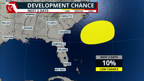 The remnants of a cold front could leave enough energy behind over the western Atlantic to ignite tropical storm activity east of Florida. What are the chances of this system developing, and where could it go?


-
 Arthur became the first named system of the season, but in less than 6 hours after being named, it moved over land in Texas. The flash flood threat continues for the next couple of days across the Southeast.
 -
 Extremely hot temperatures and a late-afternoon storm make it hard for firefighters to contain the Quarry 2 fire burning in the Everglades, producing hazy skies, poor air quality, and burnt smells across South Florida.
 -
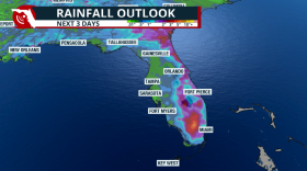
 Heavy rains threaten the Gulf Coast states, from Southeast Texas through the Deep South. Heavy rains could affect parts of the western Florida Panhandle.
 -
 Storm chances ramp up this afternoon across South Florida. Lightning could delay the first soccer match played in South Florida.
 -
 Dangerous heat is coming to North Florida and the Panhandle this weekend; the heat risk moves south next week.
 -
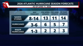 Colorado State lowers its 2026 Hurricane Season forecast due to a strong El Niño developing during the season. What does this mean?
 -
 Low rain chances for most of Florida & temperatures could feel like the triple digits across many areas this weekend. Read your forecast here.
 -
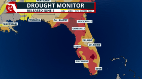 The exceptional drought has been cut in half! But not all rain has been accounted for in this drought report.
 -
 While a rare cold front will bring drier air across the northern half of the state, rain could meander across South Florida for the weekend, and winds bring hazardous conditions along the beaches.
 -
 Days of rain across Florida as tropical moisture arrives and increases the flood threat.


