
Rain chances ramp up across Florida as storms built earlier in the afternoon and even triggered flood advisories across South Florida and Central Florida. There’s plenty of moisture across much of the peninsula on Sunday. We have a surge of moisture coming in from the south and a weak frontal boundary that has pushed in from the north. This interaction will ignite more thunderstorm activity across the state.

The higher chance for flash flooding will remain focused along Florida's east coast, from Jacksonville south to Miami, mainly along the I-95 corridor. But there’s also a chance for some isolated severe thunderstorms to develop throughout the afternoon hours, especially across parts of Northeast Florida, extending toward the northern fringe of Central Florida and through the Space Coast. Some thunderstorms could turn severe, with the main threat being damaging winds of at least 58 mph. All of these threats will remain focused across the peninsula through Sunday and into the early evening hours.
Hear thunder? Sunday is active across much of the Florida Peninsula, with many thunderstorms building early this afternoon. More coverage through the next few hours. Flash flood risk along the East Coast possible. pic.twitter.com/P4XzW1gB6X
— Florida Public Radio Emergency Network (FPREN) (@FloridaStorms) July 26, 2026
Some of the showers will be moving slowly, mainly from west to east, especially across Central Florida. Therefore, high rainfall amounts could fall over the same areas repeatedly or within a short amount of time, which could trigger flash flooding. Make sure to avoid any flooded areas, especially those that tend to flood easily. As we move into the beginning of the week, rain chances will remain higher than normal, especially across the Tampa Bay area and South Florida.
Notice how the deep moisture stays put over Florida, with a deeper impulse arriving from north to south toward the middle of the week, covering the Panhandle, North, and Central Florida. This means the instability will remain & bring higher-than-normal rain chances. pic.twitter.com/357DvNrzw1
— Florida Public Radio Emergency Network (FPREN) (@FloridaStorms) July 26, 2026
There will still be plenty of moisture available at the surface and throughout the atmosphere, creating enough instability that, combined with the heat, will help develop afternoon thunderstorms. On Monday, there will once again be a chance for late morning and early afternoon storms developing across parts of the I-4 corridor between Tampa and Orlando, continuing through the afternoon hours. Across the Panhandle, a few isolated thunderstorms will also be possible Monday night.
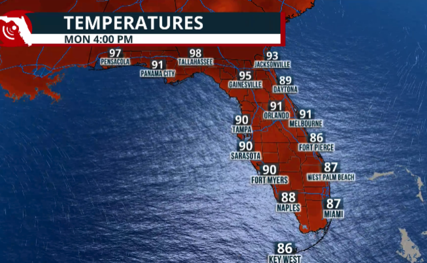
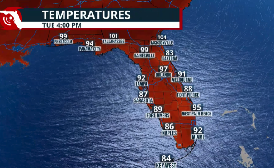

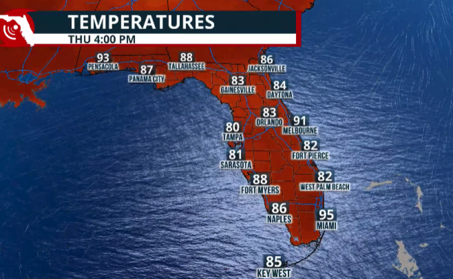
Read more: Dangerous heat across the Panhandle to start the week
For South Florida, the chance for showers and thunderstorms continues on Tuesday, with higher rain chances this time impacting the metro areas of Southeast Florida. As the winds become mainly southwesterly, moisture and thunderstorms will likely be pushed from west to east. Therefore, expect higher rain chances and greater thunderstorm coverage, especially during the afternoon hours across the metropolitan areas from Palm Beach County south to Miami.

These are beneficial rains to critically dry areas
This week's shower and thunderstorm activity is highly welcomed, especially because much of the rain is expected to fall over areas that need it the most. The Tampa Bay area, extending just north of Punta Gorda, continues to be under extreme drought, and parts of South Florida have also seen worsening drought conditions, especially across southeastern areas and the interior portions of Miami-Dade and Broward counties. So far, the forecast indicates that the heaviest showers and thunderstorms will be mainly focused across these areas during the beginning of the week.

For the next five days, rainfall totals indicate that some areas along the Gulf Coast could receive between 3 and 5 inches of rain from Sunday through Thursday. Similar rainfall amounts are also expected across parts of the Treasure Coast, Palm Beach County, and portions of Miami-Dade and Broward counties. We will continue to monitor the weather closely and bring you updates throughout the week.
