Justin Ballard
MeteorologistJustin Ballard was a Meteorologist for FPREN from 2021-2023.
-
 Meteorologist Justin Ballard/Storm Prediction CenterThursday brings another round of strong and severe storms to the Panhandle and North Florida.
 -
 Meteorologist Justin Ballard/Florida Public Radio Emergency NetworkAn unusual pattern for mid-June promises to bring several rounds of strong and severe thunderstorms to the Panhandle and North Florida through week's end.


-
 A high risk of rip currents will make for dangerous beach conditions through the Memorial Day weekend.
 -
 Several rounds of strong storms and heavy rain are possible this week across the Sunshine State.
 -
 The first 7-day Tropical Weather Outlook was published at 8 a.m. Monday, May 15.
 -
 As summer-like heat builds this week across the Sunshine State, an approaching cold front is expected to result in widespread storms by Wednesday.
 -
 National Hurricane Preparedness Week is underway and seeks to get residents prepared for whatever the upcoming hurricane season may bring.
 -
 A series of stalled frontal boundaries will set the stage for periods of heavy rain and strong thunderstorms, especially across the Florida Peninsula.
 -
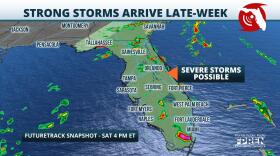 An approaching cold front will allow for strong storms to develop during the heating of the day Saturday.
 -
 Strong storms and flooding are possible, especially along and east of I-75 through Thursday evening.
 -
 Above average temperatures and below average rainfall have resulted in expanding drought conditions in the Sunshine State.
 -
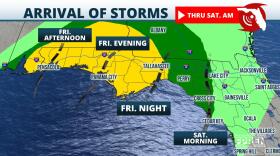 A cold front will bring the potential for strong storms to the Panhandle and parts of North Florida Friday into early Saturday.


